Agisoft Metashape
Intelligentphotogrammetry
Agisoft Metashape is a cutting-edge software solution, with its engine core driving photogrammetry to its ultimate limits, while the whole system is de-signed to deliver industry specific results relying on machine learning techni-ques for post-processing and analysis tasks.The software allows to process images from RGB or multispectral cameras, including multi-camera systems, into the high-value spatial information in the form of dense point clouds, textured polygonal models, georeferenced true orthomosaics and DSMs/DTMs. Further post-processing enables to eli-minate shadows and texture artifacts from the models, calculate vegetation indices and extract information for farming equipment action maps, auto-matically classify dense point clouds, etc.
Very fast& highly accurate
Based on the state-of-the-art technology developed by Agisoft, Metashape allows for very fast processing, providing at the same time consistent and highly accurate results both for aerial and close-range photography (up to 3cm for aerial, and up to 1mm for close-range photography).
Local or cloudprocessing
Agisoft Metashape is capable of processing of 50 000+ photos across a local cluster, thanks to distributed processing functionality. Alternatively, the project can be easily sent to the cloud to minimize hardware investment, with all the processing options being still available.
Intuitive UI& stereo mode
The software package has a linear project-based workflow that is intuitive and can be easily mastered even by a non-specialist, while pro-fessional photogrammetrists can benefit from advanced features like stereo mode and have complete control over the results accuracy, with detailed report being genera-ted at the end of processing.
Dense Cloud Based Out-of-Core Mesh Generation in Arbitrary Mode
New dense cloud based mesh generation algorithm in Metashape 1.8 is imple-mented in out-of-core style, which allows to generate mesh model even fora dense cloud with hundreds of millions of points on a machine witha moderate amount of RAM.This polygonal model generation approach is suitable for projects with manually edited or imported dense point cloud or when only designated dense point cloud classes should be used for mesh reconstruction.
Prescription Maps Calculationand Export
Metashape 1.8 allows for prescription maps calculation based on NVDI ortho-mosaic generated in the software or imported from an external source. The prescription maps as multi-polygon shape files can be exported in industry standard SHP format, with the meta information saving the fertilizer rate to be used for the area and mean index value for the given zone. Index value range for each vegetation zone can be calculated automatically or set manually based on the NDVI histogram.
Wide Range of Geospatial Data Formats Supported in Agisoft Viewer
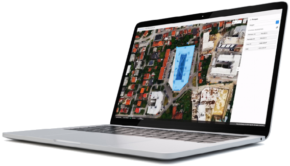
Improved Agisoft Viewer is released with Metashape 1.8 as a stand-alone software for visualization of the photogrammetric results such as tiled and polygonal models, point clouds, elevation models and orthomosaics. Agisoft Viewer supports wide range of geospatial data formats. Data from different sources can be displayed at the same time allowing to combine processing results from Metashape and external 3D (raster and vector) data. Software tools enable to create vector layers with annotations and perform distance, profile, area and volume measurements.
Measurements and Annotations in Agisoft Cloud
Agisoft Cloud offers photogrammetric processing based on Metashape algorithms in cloud infrastructure. Agisoft Cloud functionality for published projects is further extended with photo inspection capability, tools to draw and annotate vector shapes and to perform distance and area measurements.
Seamless orthomosaic for Surveying & Mapping
Metashape is a perfect tool for aerial imagery processing. The functionality of the program is being constantly developed according to the tasks set by rapidly emerging UAS industry. Metashape has proved to be a professional level post-processing tool capable of dense point clouds generation and classification for further exceptionally detailed DSMs/DTMs calculations and high-resolution seamless orthomosaics export, not to mention reconstruction of precise polygonal models of large scale objects. It is an indispensable part of GIS workflow starting with a UAV system.
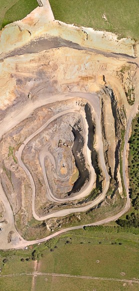
Highly accurate measurements for Mining & Quarrying
Highly accurate DEMs produced by Metashape lay the grounds for precise area and volume measurements, both for excavations and piles. Once multiple f lights performed at different time moments, Metashape allows for volume change tracking, soil erosion and glacier studies. Automatic non-coded targets detection capability saves up on manual work in inspection projects done on a regular basis
Customized vegetation index calculation for Precision Agriculture & Environmental Management
With support for panchromatic, multispectral and thermal imagery, Metashape seamlessly integrates into workflows involving processing of data from diverse sources, like vegetation and soil analysis, fires and night studies, etc. Vegetation indices calculation according to a user-defined formula allows to analyze crop problems and generate prescriptions for variable rate farming equipment.
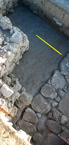
Consumer camera support for Archaeology & Documentation
Archaeology more and more often relies on photogrammetric approaches today, be it a need to model an artifact or a demand for an excavation mapping. Thanks to the capability to process imagery from any digital camera, Metashape is widely used in various archaeological projects both up in the mountains and deep under the water, including special researches like greenery pattern studies to find ancient ruins under the ground or rock art documentation and analysis projects.
Oblique imagery support for Architecture & Cultural Heritage Preservation
Numerous projects prove that Metashape is a quality tool to solve the tasks of facade and building modeling. With support for oblique imagery processing, Metashape allows to reconstruct the whole building, which can be employed for virtual tours creation, with reconstruction results being exhibited as illustrative models of largescale cultural heritage objects. 3D models of partially ruined monuments and artifacts generated with Metashape present reliable basis for restoration works thanks to exceptional accuracy of reconstruction results.
Castle Spangenberg by Aibotix GmbH
www.aibotix.com
www.aibotix.com
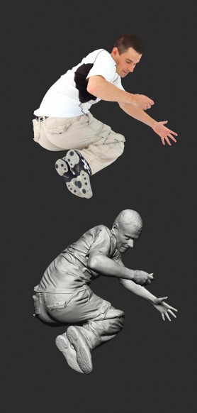
Photorealistic textures for Visual Effects & Game Design
Thanks to being highly detailed and photorealistic, Metashape models meet the strict requirements of professional animation studios, which successfully employ the software for movie and game production. Face and body capture results, being among the most demanded ones, prove that Metashape potential goes beyond one’s imagination.
Human scan by Infinite Realities
www.ir-ltd.net
www.ir-ltd.net
Licensing Options
Metashape is a proprietary software solution. The software and documentation are supplied electronically. You will receive a registration code by e-mail after your order is processed. This registration code allows to convert a demo Metashape version into a fully featured registered version.
Agisoft offers rehostable node-locked and floating licenses. Metashape license is NOT time-limited.
Metashape license includes 12 month of e-mail based technical support and entitles the licensee to free updates of the software up to the version 1.9.x (see the current released version number at Installer page).
Metashape license includes 12 month of e-mail based technical support and entitles the licensee to free updates of the software up to the version 1.9.x (see the current released version number at Installer page).
Node-Locked License
Node-Locked License (previously called Stand-Alone license) is a rehostable node-locked license, i.e. one license allows to activate the program at one machine only, however, the license can be transferred to a different computer if needed. Node-Locked license allows to use Metashape software in all kinds of paid and unpaid projects. The license is available both to individuals and legal entities, such as companies, firms, museums, research institutions, governmental institutions, etc.
To support education in the field of photogrammetry, Agisoft offers educational licenses to educational institutions. Please remember that Metashape license does not allow to provide access to the software to the third parties, in particular, over the Internet, including, without limitation, in connection with a web hosting, commercial time sharing, service bureau, or similar service.
Floating License
Floating license allows to install the program on as many computers as desired and run it, at any one time, on as many systems as the number of licenses purchased indicates. One computing machine shall be designated as the "license server"; the license server utility installed on it will manage license distribution across the network of computers where the program has been installed. Floating license is available for Agisoft Metashape Professional Edition only.
Educational License
Educational licenses (rehostable node-locked) and Educational Floating licenses are available exclusively to accredited educational institutions, their employees and students of such institutions. Only officially accredited educational institutions are eligible to obtain Agisoft Metashape educational licenses. This includes: universities, colleges, junior colleges, scientific and technical schools, vocational schools, and correspondence schools. Educational or Educational Floating licenses can also be purchased by students and officially employed teaching and research staff of officially accredited educational institutions. Any educational license prohibits all commercial uses of the software. Educational / Educational Floating and Node-Locked / Floating licenses differ legally but are technically identical.

Buy now
Agisoft Metashape
")
")
")