CADdy Geomatics Swimming Surveyor 2


CADdy Geomatics Swimming Surveyor 2
CADdy Akademie
Behind the name ‘CADdy Akademie’ you will find our complete competence in training. Software is always as good as a user can operate it. The same applies to surveying procedures: a well trained user will get the best result fast and easy. Every workflow has its own characteristics, and small mistakes mostly result in vast decreases of effort and work time. As we want to help you to save money and time, our training programme is not only based on theory but on real projects and on our wide experience.
Within our concept ‘Learn and Earn’, you won’t only get the best training. You also will receive the technology adapted to your needs.
Swimming Surveyor Workflow
Our ‘Swimming Surveyor Workflow’ is a seminar lasting two days, in which we will show you the complete workflow, beginning with mission planning, then continuing with boating, recording of depth – data, merging of RTK – GNSS –data with your recorded data and finally importing these results into an existing CAD – System.
The seminar is not limited to the pure sensor technology. The most important thing in working as a professional is knowing the subtleties of how to get a proper result and how a useful mission planning looks like.
We show you different applications of a boat in mod-ern surveying and how you can save money and time with this technology. Furthermore, we are acting independent from certain software solutions and technologies. Several solutions for mission planning as well as evaluation solutions will be shown within the seminar.
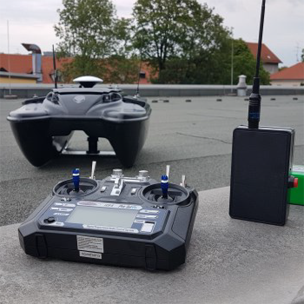
Measure Technology
The big brother of the Surveyor 1 - built for rough waters and accurate results. Equipped with everything a survey boat needs:
Hull 93 x 63 x 34 cm, ABS catamaran construction
Engines: 2 powerful moors with 11.000rpm -
Screws 2x70 mm with protection -
CPU based on Pixhawk2, control with Towerapp or similar
Data storage on SD card cumulated (position and depth at the same time) Remote control Range about 500 m above water
Fixing prism possible (tracking by electronic total station)
Power supply with 2x 20000 4s Lipos (max 16.6V) Running time approx. 5 hours. In addition, the boat will be delivered with another set of 2x 20AH, practically as emergency power supply
Sonar: Airmar Triducer DST800 very accurate depth measurement. speed and temperature record. In addition, a Deeper Sonar as a second sonar Positioning DifferentialGPS from drone technology Base / Roversystem
Planning
The real interesting thing
– besides our great price-performance-ration –
is WebCADdy, which can be used as a mission planning tool. WebCADdy pro-vides the possibility to create a simple orthophoto deriving from one or several photographs. Hence, you are able to provide an up-to-date aerial photo
Evaluation and Data Export
Like the mission planning, the evaluation of the Deeper - data occurs by saving in a cloud.
Afterwards, all data is imported into the WebCAD-dy - database where it can be edited. With the ex-port into a certain target system the projection and coordinate system will be determined. In the target system, the processing of the depth contours and the DGM (digital elevation model) takes place.
")
")
")